For more than 200 years, the map of the Canton of Zurich which Hans Conrad Gyger (1599-1674) completed in 1667 remained one of the most innovative cartographical productions of its age. In 1879 Dr Rudolf Wolf, the first Director of ETH Library, even described it as, “easily the fairest flower that cartography has perhaps ever sprouted”. An 1891 reproduction has now been included on an innovative ETH Library platform.
But back to the original: after thirty-eight years in the making under strict secrecy, Hans Conrad Gyger finally completed two versions of Zurich cantonal map in 1667: one as an oil painting, the other as a lightly coloured ink drawing on fifty-six sheets. Depending on the source, sometimes one map served as a template for its counterpart, sometimes the other. Given the long production time, however – at least according to the assumptions of Rudolf Wolf and, until the mid-twentieth century, also sections of the cartographical scene – the fifty-six sheets most likely served as a template for the complete copy, which was pieced-together and “painted” over. Gyger, whose father was a glass and enamel painter, initially followed in his father’s footsteps, but was also interested in cartography and the art of surveying. His cantonal map of Zurich was so accurate that the Gyger Map’s distortion grid could only be improved by cantonal measurements taken in around 1850 (the so-called “Wild Map”).
ETH Library owns two reproductions of the fifty-six sheets: the limited edition facsimile print Karte des Kantons Zürich aus dem Jahr 1667 in 56 Blättern produced in 1967 to mark the 300th anniversary of the map’s completion, and the reproduction Hans Konrad Gyger’s Züricher-Cantons-Carte 1667 published by Hofer & Burger against the backdrop of the International Geographical Congress in Bern in 1891.
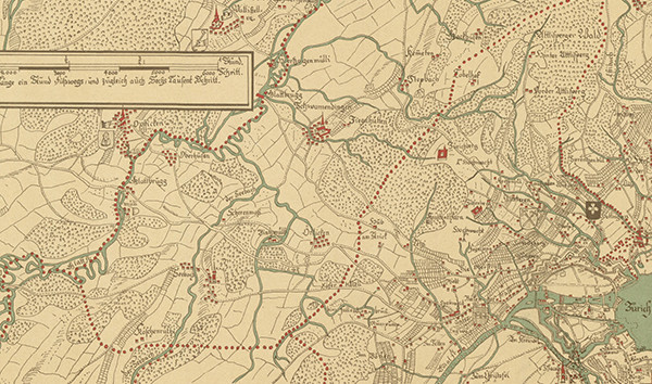
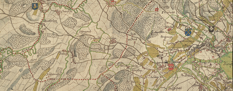
Figs. 1 and 2: Sections from the 1891 (top, sheet 29) and 1967 (bottom, sheet d4) reproductions.
Researchers originally assumed that no reproductions had been possible for so long owing to the dimensions of the map. In 1971, however, Arthur Dürst proved that the aforementioned facsimiles of the fifty-six map sheets from 1891 and 1967 may actually have been based on a copy of the large oil painting produced in 1702 and thus can’t have stemmed from Gyger himself. Nonetheless, the Gyger Map remains a masterpiece – both in the original and as copies, not to mention more recent reproductions – and helped shape Swiss cartography in the seventeenth and eighteenth centuries.
Meanwhile, the 1891 reproduction has been digitised by ETH Library and uploaded to e-rara.ch. The resulting digital copies of the fifty-six map sheets are currently being indexed for ETHorama. This new platform facilitates innovative, geographical access to digital documents from ETH Library with ties to Switzerland. Fittingly for the International Map Year and the significance of the Gyger Map, ETH Library provides intuitive access to cartographical materials, but also texts and images, via an interactive map and presents them to a wider public. The indexing work on the Gyger Map reproduction has made great strides in this respect. In the course of the year, additional digitised maps related to Switzerland will join the 356 map sheets already available on ETHorama (as of mid-January 2016).
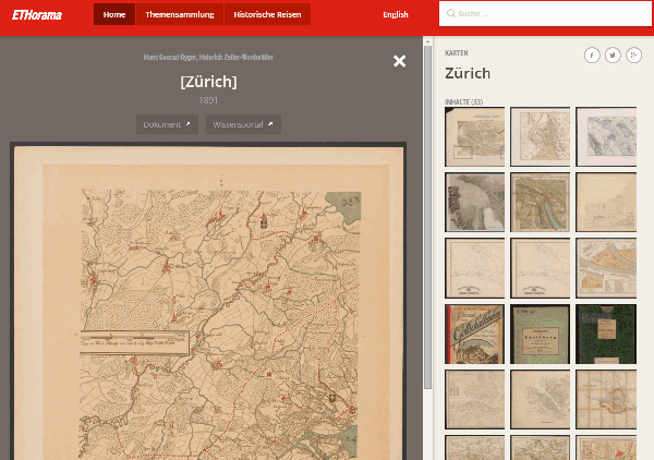
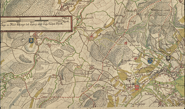
Fig. 3: Sheet 29 [Zurich] of the Gyger Map on ETHorama
Further reading:
- Wolf, Rudolf (1879): Geschichte der Vermessungen in der Schweiz. Zürich: Commission von S. Höhr.
- Fueter, Eduard (1941): Grosse Schweizer Forscher. Zürich: Atlantis.
- Dürst, Arthur (1971): Hans Conrad Gygers grosse Karte des Zürcher Gebiets von 1667, in: Zürcher Taschenbuch, Jg. 91 (1971), S. 31-42.